


Grenier

katiab
User
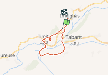

Length
7.8 km

Max alt
1986 m

Uphill gradient
216 m
Km-Effort
10.6 km

Min alt
1837 m

Downhill gradient
199 m
Boucle
No
Creation date :
2022-10-05 08:25:17.04
Updated on :
2022-10-05 11:19:08.27
2h53
Difficulty : Medium

FREE GPS app for hiking
 SityTrail
IGN / Geographical institutes
SityTrail Plus
The world is yours!
About
Trail Walking of 7.8 km to be discovered at Béni Mellal-Khénifra, cercle d'Azilal, Tabant. This trail is proposed by katiab.
Positioning
Country:
Morocco
Region :
Béni Mellal-Khénifra
Department/Province :
cercle d'Azilal
Municipality :
Tabant
Location:
Unknown
Start:(Dec)
Start:(UTM)
744004 ; 3506092 (29R) N.
Comments