


Méréville Clairlieu

JeanPierreNancy
User
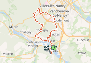

Length
36 km

Max alt
421 m

Uphill gradient
498 m
Km-Effort
42 km

Min alt
218 m

Downhill gradient
497 m
Boucle
Yes
Creation date :
2022-10-05 11:32:07.962
Updated on :
2022-10-05 14:04:36.202
2h21
Difficulty : Easy

FREE GPS app for hiking
 SityTrail
IGN / Geographical institutes
SityTrail Plus
The world is yours!
About
Trail Mountain bike of 36 km to be discovered at Grand Est, Meurthe-et-Moselle, Méréville. This trail is proposed by JeanPierreNancy.
Positioning
Country:
France
Region :
Grand Est
Department/Province :
Meurthe-et-Moselle
Municipality :
Méréville
Location:
Unknown
Start:(Dec)
Start:(UTM)
289723 ; 5385444 (32U) N.
Comments