


Concarneau Gabelous

taguette
User
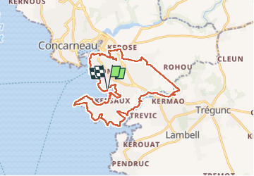

Length
18.7 km

Max alt
28 m

Uphill gradient
157 m
Km-Effort
21 km

Min alt
0 m

Downhill gradient
157 m
Boucle
Yes
Creation date :
2022-10-05 07:31:19.879
Updated on :
2022-10-05 19:07:47.608
4h54
Difficulty : Very difficult

FREE GPS app for hiking
 SityTrail
IGN / Geographical institutes
SityTrail Plus
The world is yours!
About
Trail Walking of 18.7 km to be discovered at Brittany, Finistère, Concarneau. This trail is proposed by taguette.
Positioning
Country:
France
Region :
Brittany
Department/Province :
Finistère
Municipality :
Concarneau
Location:
Unknown
Start:(Dec)
Start:(UTM)
432492 ; 5301314 (30T) N.
Comments