


Moto Collonges la Rouge

Levillefranchois
User
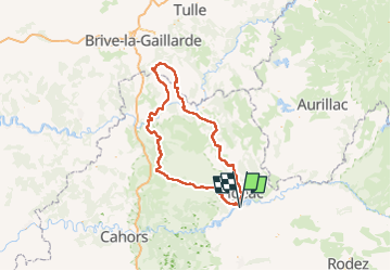

Length
208 km

Max alt
616 m

Uphill gradient
3586 m
Km-Effort
256 km

Min alt
100 m

Downhill gradient
3587 m
Boucle
Yes
Creation date :
2022-10-06 07:57:20.194
Updated on :
2022-10-06 08:14:20.949
0m
Difficulty : Easy

FREE GPS app for hiking
 SityTrail
IGN / Geographical institutes
SityTrail Plus
The world is yours!
About
Trail Motorbike of 208 km to be discovered at Occitania, Aveyron, Causse-et-Diège. This trail is proposed by Levillefranchois.
Positioning
Country:
France
Region :
Occitania
Department/Province :
Aveyron
Municipality :
Causse-et-Diège
Location:
Unknown
Start:(Dec)
Start:(UTM)
422708 ; 4934129 (31T) N.
Comments