


rochebloine Nozières boucle

elcanario
User
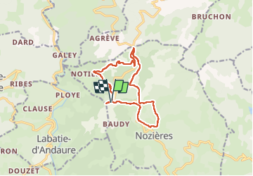

Length
12.7 km

Max alt
1032 m

Uphill gradient
440 m
Km-Effort
18.6 km

Min alt
744 m

Downhill gradient
442 m
Boucle
Yes
Creation date :
2022-10-05 09:39:48.899
Updated on :
2022-10-06 08:42:55.874
6h01
Difficulty : Very easy

FREE GPS app for hiking
 SityTrail
IGN / Geographical institutes
SityTrail Plus
The world is yours!
About
Trail Walking of 12.7 km to be discovered at Auvergne-Rhône-Alpes, Ardèche, Nozières. This trail is proposed by elcanario.
Description
Jolie randonnée, belles vues
Positioning
Country:
France
Region :
Auvergne-Rhône-Alpes
Department/Province :
Ardèche
Municipality :
Nozières
Location:
Unknown
Start:(Dec)
Start:(UTM)
619898 ; 4988477 (31T) N.
Comments