Trail Walking Nozières - rochebloine Nozières boucle - Photo

rochebloine Nozières boucle

© OpenStreetMap contributors
Length
Length
12.7 km
Max alt
Max alt
1032 m
Uphill gradient
Uphill gradient
440 m
Km-Effort
Km-Effort  
18.6 km
Min alt
Min alt
744 m
Downhill gradient
Downhill gradient
442 m
Boucle
Boucle
Yes
Creation date :
2022-10-05 09:39:48.899
Updated on :
2022-10-06 08:42:55.874

(0 Reviews)

Walking
Walking
6h01
Difficulty : Very easy

Scan this QR Code to open this trail in the SityTrail application

FREE GPS app for hiking

Logo SityTrail SityTrail

IGN / Geographical institutes

Download SityTrail from the App Store Download SityTrail from Google Play

Logo SityTrail SityTrail World

The world is yours!

Download SityTrail from the App Store Download SityTrail from Google Play Download SityTrail on Huawei AppGallery

About

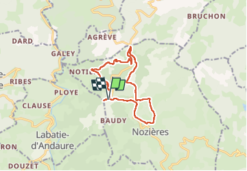
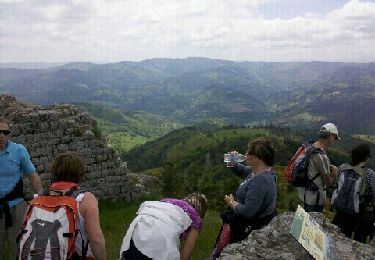
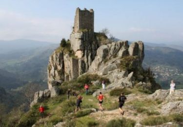
Trail Walking of 12.7 km to be discovered at Auvergne-Rhône-Alpes, Ardèche, Nozières. This trail is proposed by elcanario.

Description

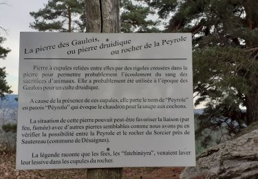
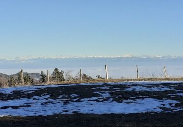
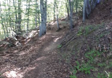
Jolie randonnée, belles vues

Elevation profile

Positioning

Country:
France
Region :
Auvergne-Rhône-Alpes
Department/Province :
Ardèche
Municipality :
Nozières
Location:
Unknown
Start:(UTM)
619898 ; 4988477 (31T) N.

Trails nearby

Trail Walking Pailharès - Pailharès - Photo
Walking
claufranck

Walking

Very easy
(1)
Pailharès, Auvergne-Rhône-Alpes, Ardèche, France
10.2 km | 16.2 km-effort
3h 28min
Yes
Trail Walking Nozières - Col du Buisson - Nozières - Photo
Walking
tracegps

Walking

Medium
Nozières, Auvergne-Rhône-Alpes, Ardèche, France
12 km | 18 km-effort
3h 30min
Yes
Trail Walking Désaignes - La Terrasse - Désaignes - Photo
Walking
tracegps

Walking

Medium
Désaignes, Auvergne-Rhône-Alpes, Ardèche, France
13.3 km | 21 km-effort
4h 0min
Yes
Trail Walking Désaignes - Les Sauvages - Desaignes - Photo
Walking
tracegps

Walking

Medium
Désaignes, Auvergne-Rhône-Alpes, Ardèche, France
12.3 km | 17.1 km-effort
3h 0min
Yes
Trail Walking Labatie-d'Andaure - Le rocher de Peyrolle Labatie d Andaure - Photo
Walking
brigitte07

Walking

Difficult
(1)
Labatie-d'Andaure, Auvergne-Rhône-Alpes, Ardèche, France
7.4 km | 12.1 km-effort
2h 1min
Yes
Trail Walking Nozières - rochebloine, col du buisson - Photo
Walking
brigitte07

Walking

Medium
Nozières, Auvergne-Rhône-Alpes, Ardèche, France
7.6 km | 11.7 km-effort
1h 59min
Yes
Trail Walking Nozières - Nozière col du buisson Raymonde - Photo
Walking
Martine 07

Walking

Difficult
Nozières, Auvergne-Rhône-Alpes, Ardèche, France
12.3 km | 17.9 km-effort
3h 35min
Yes
Trail Walking Nozières - 123456 - Photo
Walking
randodan

Walking

Very easy
Nozières, Auvergne-Rhône-Alpes, Ardèche, France
14.3 km | 21 km-effort
4h 9min
Yes
Trail Running Désaignes - Trail  l'Ardéchois 34km - édition 2010 - Photo
Running
tracegps

Running

Difficult
Désaignes, Auvergne-Rhône-Alpes, Ardèche, France
36 km | 56 km-effort
5h 0min
Yes


Close
My subscriptions