


Q6,2

aldaus
User
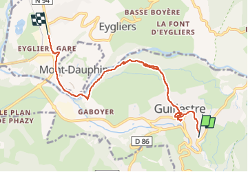

Length
7.6 km

Max alt
1058 m

Uphill gradient
111 m
Km-Effort
9.6 km

Min alt
886 m

Downhill gradient
270 m
Boucle
No
Creation date :
2022-10-06 09:25:42.367
Updated on :
2022-10-06 12:37:11.99
2h40
Difficulty : Easy

FREE GPS app for hiking
 SityTrail
IGN / Geographical institutes
SityTrail Plus
The world is yours!
About
Trail Walking of 7.6 km to be discovered at Provence-Alpes-Côte d'Azur, Hautes-Alpes, Guillestre. This trail is proposed by aldaus.
Positioning
Country:
France
Region :
Provence-Alpes-Côte d'Azur
Department/Province :
Hautes-Alpes
Municipality :
Guillestre
Location:
Unknown
Start:(Dec)
Start:(UTM)
314042 ; 4947477 (32T) N.
Comments