


sainte Marine

taguette
User
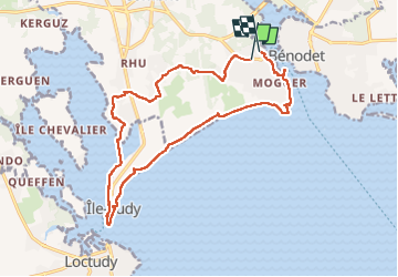

Length
17 km

Max alt
25 m

Uphill gradient
107 m
Km-Effort
18.4 km

Min alt
-2 m

Downhill gradient
111 m
Boucle
No
Creation date :
2022-10-06 09:06:36.921
Updated on :
2022-10-06 15:07:35.776
4h16
Difficulty : Medium

FREE GPS app for hiking
 SityTrail
IGN / Geographical institutes
SityTrail Plus
The world is yours!
About
Trail Walking of 17 km to be discovered at Brittany, Finistère, Combrit. This trail is proposed by taguette.
Positioning
Country:
France
Region :
Brittany
Department/Province :
Finistère
Municipality :
Combrit
Location:
Unknown
Start:(Dec)
Start:(UTM)
415892 ; 5302875 (30T) N.
Comments