


dorans

bernardrampft
User
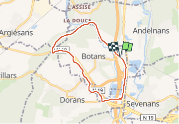

Length
6.8 km

Max alt
394 m

Uphill gradient
80 m
Km-Effort
7.8 km

Min alt
339 m

Downhill gradient
81 m
Boucle
Yes
Creation date :
2022-10-06 11:54:02.801
Updated on :
2022-10-06 19:40:13.581
2h52
Difficulty : Medium

FREE GPS app for hiking
 SityTrail
IGN / Geographical institutes
SityTrail Plus
The world is yours!
About
Trail Walking of 6.8 km to be discovered at Bourgogne-Franche-Comté, Territoire-de-Belfort, Botans. This trail is proposed by bernardrampft.
Description
randonnée ça ile
Positioning
Country:
France
Region :
Bourgogne-Franche-Comté
Department/Province :
Territoire-de-Belfort
Municipality :
Botans
Location:
Unknown
Start:(Dec)
Start:(UTM)
338951 ; 5273676 (32T) N.
Comments