


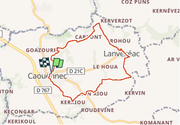
Caouennec

0658294C
User

Length
7.6 km

Max alt
102 m

Uphill gradient
76 m
Km-Effort
8.6 km

Min alt
46 m

Downhill gradient
75 m
Boucle
Yes
Creation date :
2022-10-07 12:00:17.0
Updated on :
2022-10-07 14:10:10.408
2h09
Difficulty : Medium

FREE GPS app for hiking
 SityTrail
IGN / Geographical institutes
SityTrail Plus
The world is yours!
About
Trail Walking of 7.6 km to be discovered at Brittany, Côtes-d'Armor, Caouënnec-Lanvézéac. This trail is proposed by 0658294C.
Positioning
Country:
France
Region :
Brittany
Department/Province :
Côtes-d'Armor
Municipality :
Caouënnec-Lanvézéac
Location:
Unknown
Start:(Dec)
Start:(UTM)
472502 ; 5394686 (30U) N.
Comments