


la table fermière

Mascart
User
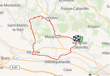

Length
32 km

Max alt
269 m

Uphill gradient
338 m
Km-Effort
36 km

Min alt
104 m

Downhill gradient
320 m
Boucle
No
Creation date :
2022-10-07 12:57:30.311
Updated on :
2022-10-07 15:21:28.902
2h23
Difficulty : Medium

FREE GPS app for hiking
 SityTrail
IGN / Geographical institutes
SityTrail Plus
The world is yours!
About
Trail Road bike of 32 km to be discovered at Occitania, Aude, Ventenac-Cabardès. This trail is proposed by Mascart.
Description
boucle alzonne montolieu
Positioning
Country:
France
Region :
Occitania
Department/Province :
Aude
Municipality :
Ventenac-Cabardès
Location:
Unknown
Start:(Dec)
Start:(UTM)
441036 ; 4790398 (31T) N.
Comments