


Bsa tour

pierre.chau
User
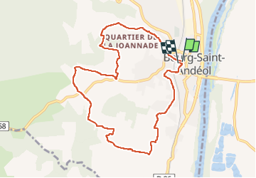

Length
9.8 km

Max alt
179 m

Uphill gradient
226 m
Km-Effort
12.8 km

Min alt
61 m

Downhill gradient
226 m
Boucle
Yes
Creation date :
2022-10-08 08:13:34.0
Updated on :
2022-10-08 10:13:03.415
1h58
Difficulty : Difficult

FREE GPS app for hiking
 SityTrail
IGN / Geographical institutes
SityTrail Plus
The world is yours!
About
Trail Walking of 9.8 km to be discovered at Auvergne-Rhône-Alpes, Ardèche, Bourg-Saint-Andéol. This trail is proposed by pierre.chau.
Positioning
Country:
France
Region :
Auvergne-Rhône-Alpes
Department/Province :
Ardèche
Municipality :
Bourg-Saint-Andéol
Location:
Unknown
Start:(Dec)
Start:(UTM)
630896 ; 4914413 (31T) N.
Comments