


Marathon relais st vulnas 20221008

Valery01
User
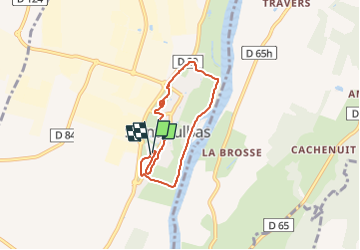

Length
5.7 km

Max alt
211 m

Uphill gradient
41 m
Km-Effort
6.2 km

Min alt
192 m

Downhill gradient
41 m
Boucle
Yes
Creation date :
2022-10-08 12:01:35.0
Updated on :
2022-10-08 12:58:15.906
56m
Difficulty : Unknown

FREE GPS app for hiking
 SityTrail
IGN / Geographical institutes
SityTrail Plus
The world is yours!
About
Trail Trail of 5.7 km to be discovered at Auvergne-Rhône-Alpes, Ain, Saint-Vulbas. This trail is proposed by Valery01.
Positioning
Country:
France
Region :
Auvergne-Rhône-Alpes
Department/Province :
Ain
Municipality :
Saint-Vulbas
Location:
Unknown
Start:(Dec)
Start:(UTM)
677636 ; 5077490 (31T) N.
Comments