Trail Horseback riding Pressins - 202210 RallyePressin J1 - Photo

202210 RallyePressin J1

 xhakon
xhakon

User

© OpenStreetMap contributors
Length
Length
26 km
Max alt
Max alt
564 m
Uphill gradient
Uphill gradient
530 m
Km-Effort
Km-Effort  
33 km
Min alt
Min alt
269 m
Downhill gradient
Downhill gradient
540 m
Boucle
Boucle
Yes
Creation date :
2022-10-08 08:04:14.765
Updated on :
2022-10-08 13:49:52.35

(0 Reviews)

Horseback riding
Horseback riding
3h30
Difficulty : Medium

Scan this QR Code to open this trail in the SityTrail application

FREE GPS app for hiking

Logo SityTrail SityTrail

IGN / Geographical institutes

Download SityTrail from the App Store Download SityTrail from Google Play

Logo SityTrail SityTrail World

The world is yours!

Download SityTrail from the App Store Download SityTrail from Google Play Download SityTrail on Huawei AppGallery

About

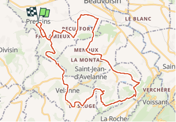
Trail Horseback riding of 26 km to be discovered at Auvergne-Rhône-Alpes, Isère, Pressins. This trail is proposed by xhakon.

Description

Quelques très beaux chemins, paysages et dénivelés variés, mais beaucoup de route.

Elevation profile

Positioning

Country:
France
Region :
Auvergne-Rhône-Alpes
Department/Province :
Isère
Municipality :
Pressins
Location:
Unknown
Start:(UTM)
705209 ; 5044418 (31T) N.

Trails nearby

Trail Walking Velanne - Boucle autour de sauge - Photo
Walking
choubaka77

Walking

Very easy
Velanne, Auvergne-Rhône-Alpes, Isère, France
5.7 km | 7.2 km-effort
1h 33min
Yes
Trail Walking Montferrat - Pays Voironnais - Circuit GPS de la Roselière - Photo
Walking
tracegps

Walking

Difficult
Montferrat, Auvergne-Rhône-Alpes, Isère, France
12 km | 16.6 km-effort
2h 45min
Yes
Trail Horseback riding Pressins - 202210 RallyePressins J2 - Photo
Horseback riding
xhakon

Horseback riding

Medium
Pressins, Auvergne-Rhône-Alpes, Isère, France
15.7 km | 21 km-effort
2h 30min
Yes
Trail Horseback riding Les Abrets en Dauphiné - 202210 ApprochePressinsJ1 LesAbrets-Palladru - Photo
Horseback riding
xhakon

Horseback riding

Medium
Les Abrets en Dauphiné, Auvergne-Rhône-Alpes, Isère, France
27 km | 37 km-effort
5h 0min
No
Trail Walking Les Abrets en Dauphiné - m'ont rond -montferrat - Photo
Walking
goizet

Walking

Easy
Les Abrets en Dauphiné, Auvergne-Rhône-Alpes, Isère, France
3 km | 4.1 km-effort
1h 55min
Yes
Trail Other activity Le Pont-de-Beauvoisin - pont 1 - Photo
Other activity
trailer38

Other activity

Very easy
Le Pont-de-Beauvoisin, Auvergne-Rhône-Alpes, Savoy, France
7 km | 8.4 km-effort
43min
Yes
Trail Cycle Le Pont-de-Beauvoisin - 20120801 Milles marthyrs i - Photo
Cycle
TaxiMarne

Cycle

Difficult
Le Pont-de-Beauvoisin, Auvergne-Rhône-Alpes, Savoy, France
48 km | 61 km-effort
3h 9min
Yes
Trail Mountain bike Les Abrets en Dauphiné - Sortie vtt 1 - Photo
Mountain bike
choubaka77

Mountain bike

Easy
Les Abrets en Dauphiné, Auvergne-Rhône-Alpes, Isère, France
11.4 km | 14.4 km-effort
54min
Yes
Trail Road bike Les Abrets en Dauphiné - Sortie vélo - Photo
Road bike
choubaka77

Road bike

Easy
Les Abrets en Dauphiné, Auvergne-Rhône-Alpes, Isère, France
38 km | 45 km-effort
2h 16min
Yes


Close
My subscriptions