


3345 OT - Signes - col des glacieres

Yot
User
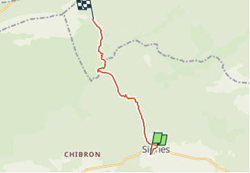

Length
8 km

Max alt
857 m

Uphill gradient
668 m
Km-Effort
15.1 km

Min alt
335 m

Downhill gradient
149 m
Boucle
No
Creation date :
2022-10-08 17:02:03.89
Updated on :
2022-12-02 10:35:52.25
3h26
Difficulty : Difficult

FREE GPS app for hiking
 SityTrail
IGN / Geographical institutes
SityTrail Plus
The world is yours!
About
Trail Walking of 8 km to be discovered at Provence-Alpes-Côte d'Azur, Var, Signes. This trail is proposed by Yot.
Positioning
Country:
France
Region :
Provence-Alpes-Côte d'Azur
Department/Province :
Var
Municipality :
Signes
Location:
Unknown
Start:(Dec)
Start:(UTM)
732104 ; 4796883 (31T) N.
Comments