


Mazères fait 2022

pidjam
User
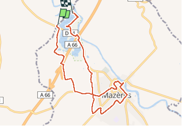

Length
10.2 km

Max alt
244 m

Uphill gradient
75 m
Km-Effort
11.2 km

Min alt
218 m

Downhill gradient
75 m
Boucle
No
Creation date :
2022-10-09 07:16:04.688
Updated on :
2022-10-09 11:51:10.269
4h29
Difficulty : Easy

FREE GPS app for hiking
 SityTrail
IGN / Geographical institutes
SityTrail Plus
The world is yours!
About
Trail Walking of 10.2 km to be discovered at Occitania, Ariège, Mazères. This trail is proposed by pidjam.
Positioning
Country:
France
Region :
Occitania
Department/Province :
Ariège
Municipality :
Mazères
Location:
Unknown
Start:(Dec)
Start:(UTM)
391070 ; 4791403 (31T) N.
Comments