


Forêt de Turpin

tataouaoua
User
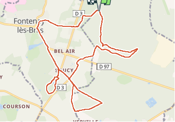

Length
12.8 km

Max alt
165 m

Uphill gradient
185 m
Km-Effort
15.2 km

Min alt
89 m

Downhill gradient
186 m
Boucle
Yes
Creation date :
2022-10-09 11:23:35.61
Updated on :
2022-10-09 15:10:24.456
3h12
Difficulty : Medium

FREE GPS app for hiking
 SityTrail
IGN / Geographical institutes
SityTrail Plus
The world is yours!
About
Trail Walking of 12.8 km to be discovered at Ile-de-France, Essonne, Bruyères-le-Châtel. This trail is proposed by tataouaoua.
Positioning
Country:
France
Region :
Ile-de-France
Department/Province :
Essonne
Municipality :
Bruyères-le-Châtel
Location:
Unknown
Start:(Dec)
Start:(UTM)
439527 ; 5385843 (31U) N.
Comments