


Plancher Bas R.P. Du 09/10/22

Danielj
User
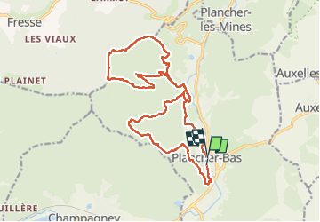

Length
19.7 km

Max alt
849 m

Uphill gradient
624 m
Km-Effort
28 km

Min alt
420 m

Downhill gradient
620 m
Boucle
No
Creation date :
2022-10-09 07:58:19.0
Updated on :
2022-10-09 16:40:10.199
6h17
Difficulty : Very difficult

FREE GPS app for hiking
 SityTrail
IGN / Geographical institutes
SityTrail Plus
The world is yours!
About
Trail Walking of 19.7 km to be discovered at Bourgogne-Franche-Comté, Haute-Saône, Plancher-Bas. This trail is proposed by Danielj.
Positioning
Country:
France
Region :
Bourgogne-Franche-Comté
Department/Province :
Haute-Saône
Municipality :
Plancher-Bas
Location:
Unknown
Start:(Dec)
Start:(UTM)
329933 ; 5287587 (32T) N.
Comments