


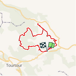
St Pierre de Tourtour -Source de Fontigon

Sugg
User

Length
17.4 km

Max alt
768 m

Uphill gradient
260 m
Km-Effort
21 km

Min alt
641 m

Downhill gradient
260 m
Boucle
Yes
Creation date :
2019-03-22 17:00:02.774
Updated on :
2019-03-22 17:00:03.041
4h33
Difficulty : Medium

FREE GPS app for hiking
 SityTrail
IGN / Geographical institutes
SityTrail Plus
The world is yours!
About
Trail Walking of 17.4 km to be discovered at Provence-Alpes-Côte d'Azur, Var, Ampus. This trail is proposed by Sugg.
Description
Reco future Rando Restons en forme.
Des zones privées à l'EST impose un changement d'itinéraire et la réalisation d'un nouveau parcours.
Il manque pas mal de pistes sur la carte, adaptations possibles.
Photos


Positioning
Country:
France
Region :
Provence-Alpes-Côte d'Azur
Department/Province :
Var
Municipality :
Ampus
Location:
Unknown
Start:(Dec)
Start:(UTM)
285371 ; 4830963 (32T) N.
Comments