


Xhoris

lepi
User
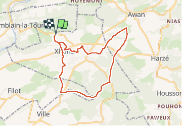

Length
14.8 km

Max alt
356 m

Uphill gradient
319 m
Km-Effort
19.1 km

Min alt
216 m

Downhill gradient
318 m
Boucle
Yes
Creation date :
2022-10-10 07:57:08.756
Updated on :
2022-10-10 13:12:53.77
4h11
Difficulty : Easy

FREE GPS app for hiking
 SityTrail
IGN / Geographical institutes
SityTrail Plus
The world is yours!
About
Trail Walking of 14.8 km to be discovered at Wallonia, Liège, Ferrières. This trail is proposed by lepi.
Positioning
Country:
Belgium
Region :
Wallonia
Department/Province :
Liège
Municipality :
Ferrières
Location:
Unknown
Start:(Dec)
Start:(UTM)
684332 ; 5591972 (31U) N.
Comments