


Charentay (17 km - D. 505 m)

Thomasdanielle
User
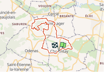

Length
16.9 km

Max alt
482 m

Uphill gradient
504 m
Km-Effort
24 km

Min alt
194 m

Downhill gradient
507 m
Boucle
Yes
Creation date :
2022-10-10 07:31:32.0
Updated on :
2022-10-11 08:17:46.309
4h22
Difficulty : Very difficult

FREE GPS app for hiking
 SityTrail
IGN / Geographical institutes
SityTrail Plus
The world is yours!
About
Trail Walking of 16.9 km to be discovered at Auvergne-Rhône-Alpes, Rhône, Charentay. This trail is proposed by Thomasdanielle.
Description
D/A : Parking des pompiers
A voir :
Randonnée en direction de La Chapelle de Brouiilly (construite en 1854) pour protéger le vignoble contre les intempéries.
Photos
 - Photo 1")
 - Photo 2")
 - Photo 3")
Positioning
Country:
France
Region :
Auvergne-Rhône-Alpes
Department/Province :
Rhône
Municipality :
Charentay
Location:
Unknown
Start:(Dec)
Start:(UTM)
629763 ; 5105214 (31T) N.
Comments