


valsonne_reel

ppn
User
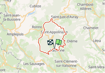

Length
23 km

Max alt
869 m

Uphill gradient
799 m
Km-Effort
34 km

Min alt
456 m

Downhill gradient
797 m
Boucle
Yes
Creation date :
2014-12-10 00:00:00.0
Updated on :
2014-12-10 00:00:00.0
3h10
Difficulty : Medium

FREE GPS app for hiking
 SityTrail
IGN / Geographical institutes
SityTrail Plus
The world is yours!
About
Trail Mountain bike of 23 km to be discovered at Auvergne-Rhône-Alpes, Rhône, Valsonne. This trail is proposed by ppn.
Description
montée initiale pénible 300m, 3km
beaux points de vue
Positioning
Country:
France
Region :
Auvergne-Rhône-Alpes
Department/Province :
Rhône
Municipality :
Valsonne
Location:
Unknown
Start:(Dec)
Start:(UTM)
610374 ; 5089365 (31T) N.
Comments