


Sources Huveaune - St Beaume

soca
User
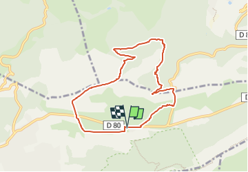

Length
8.3 km

Max alt
772 m

Uphill gradient
363 m
Km-Effort
13.1 km

Min alt
434 m

Downhill gradient
361 m
Boucle
Yes
Creation date :
2022-10-11 16:23:13.617
Updated on :
2022-10-11 16:24:39.578
3h00
Difficulty : Medium

FREE GPS app for hiking
 SityTrail
IGN / Geographical institutes
SityTrail Plus
The world is yours!
About
Trail Walking of 8.3 km to be discovered at Provence-Alpes-Côte d'Azur, Var, Plan-d'Aups-Sainte-Baume. This trail is proposed by soca.
Positioning
Country:
France
Region :
Provence-Alpes-Côte d'Azur
Department/Province :
Var
Municipality :
Plan-d'Aups-Sainte-Baume
Location:
Unknown
Start:(Dec)
Start:(UTM)
723369 ; 4801761 (31T) N.
Comments