


Chalmazel Monbrison 1.10.2022 (incomplet)

jackalv
User
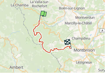

Length
37 km

Max alt
1413 m

Uphill gradient
990 m
Km-Effort
50 km

Min alt
689 m

Downhill gradient
1143 m
Boucle
No
Creation date :
2022-10-12 04:23:44.47
Updated on :
2022-10-12 04:24:15.889
9h15
Difficulty : Medium

FREE GPS app for hiking
 SityTrail
IGN / Geographical institutes
SityTrail Plus
The world is yours!
About
Trail Walking of 37 km to be discovered at Auvergne-Rhône-Alpes, Loire, Chalmazel-Jeansagnière. This trail is proposed by jackalv.
Positioning
Country:
France
Region :
Auvergne-Rhône-Alpes
Department/Province :
Loire
Municipality :
Chalmazel-Jeansagnière
Location:
Chalmazel
Start:(Dec)
Start:(UTM)
566353 ; 5061666 (31T) N.
Comments