


VTT - la Peyrouse

JMHRX2
User

Length
21 km

Max alt
1707 m

Uphill gradient
812 m
Km-Effort
31 km

Min alt
1001 m

Downhill gradient
806 m
Boucle
Yes
Creation date :
2022-10-05 08:16:29.159
Updated on :
2022-10-12 07:05:52.077
2h48
Difficulty : Difficult

FREE GPS app for hiking
 SityTrail
IGN / Geographical institutes
SityTrail Plus
The world is yours!
About
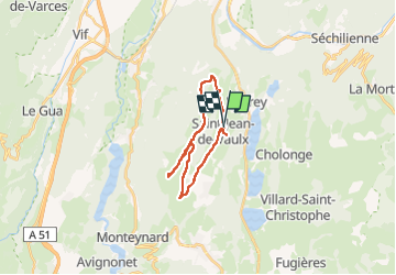
Trail Mountain bike of 21 km to be discovered at Auvergne-Rhône-Alpes, Isère, Saint-Jean-de-Vaulx. This trail is proposed by JMHRX2.
Positioning
Country:
France
Region :
Auvergne-Rhône-Alpes
Department/Province :
Isère
Municipality :
Saint-Jean-de-Vaulx
Location:
Unknown
Start:(Dec)
Start:(UTM)
717414 ; 4988243 (31T) N.
Comments