


Lesconil

taguette
User

Length
23 km

Max alt
14 m

Uphill gradient
113 m
Km-Effort
25 km

Min alt
-2 m

Downhill gradient
113 m
Boucle
Yes
Creation date :
2022-10-08 07:59:14.969
Updated on :
2022-10-12 12:28:05.95
6h15
Difficulty : Very difficult

FREE GPS app for hiking
 SityTrail
IGN / Geographical institutes
SityTrail Plus
The world is yours!
About
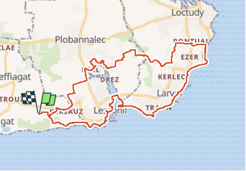
Trail Walking of 23 km to be discovered at Brittany, Finistère, Treffiagat. This trail is proposed by taguette.
Positioning
Country:
France
Region :
Brittany
Department/Province :
Finistère
Municipality :
Treffiagat
Location:
Unknown
Start:(Dec)
Start:(UTM)
406395 ; 5294493 (30T) N.
Comments