![](/images/other/stat-length.png)
![Trail Walking Fontainebleau - Canon#9 - Photo](https://media.geolcdn.com/t/1900/400/ext.pjpeg?maxdim=2&url=https%3A%2F%2Fservices.sitytrail.com%2FGeolivesWS%2FDownloadMedia.ashx%3FTrailID%3D1099670%26Media%3Dfix__20190120162913.jpg)
Canon#9
aubr
User
![Length](/images/other/stat-length.png)
Length
8.2 km
![Max alt](https://static1.geolcdn.com/siteimages/upload/files/1508320355ic_sort_altitude_max_24dp.png)
Max alt
144 m
![Uphill gradient](https://static1.geolcdn.com/siteimages/upload/files/1508320355ic_sort_den_pos_24dp.png)
Uphill gradient
127 m
![Km-Effort](/images/other/stat-length.png)
Km-Effort
9.9 km
![Min alt](https://static1.geolcdn.com/siteimages/upload/files/1508320355ic_sort_altitude_min_24dp.png)
Min alt
88 m
![Downhill gradient](https://static1.geolcdn.com/siteimages/upload/files/1508320355ic_sort_den_neg_24dp.png)
Downhill gradient
129 m
![Boucle](https://static1.geolcdn.com/siteimages/upload/files/16400158638029165_repeat_loop_refresh_sync_direction_icon.png)
Boucle
Yes
Creation date :
2022-10-13 15:31:40.872
Updated on :
2022-10-14 14:51:03.205
![Walking](https://static1.geolcdn.com/sitytour/trail-icons/101.png)
2h19
Difficulty : Medium
![Scan this QR Code to open this trail in the SityTrail application](https://capi.geolives.com/qq0zvz2zws4bq2lad0pu/sitytour/trails/3422843/qr.png?size=200)
FREE GPS app for hiking
About
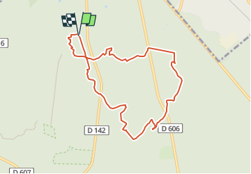
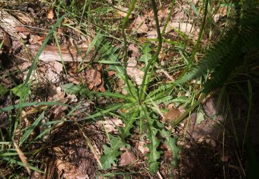
Trail Walking of 8.2 km to be discovered at Ile-de-France, Seine-et-Marne, Fontainebleau. This trail is proposed by aubr.
Description
Boucle au départ du parking du Rocher Canon Sur la D142
Elle empreinte majoritairement le Sentier 12 Est,
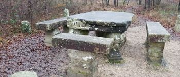
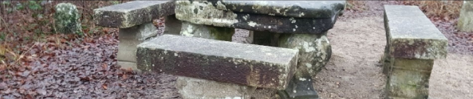
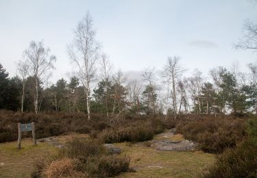
A voir la Table du Grand Maitre et la Butte Saint Louis.
Positioning
Country:
France
Region :
Ile-de-France
Department/Province :
Seine-et-Marne
Municipality :
Fontainebleau
Location:
Unknown
Start:(Dec)
Start:(UTM)
475285 ; 5367795 (31U) N.
Comments
Trails nearby
![Trail Walking Barbizon - Sentier des peintres - Photo](https://media.geolcdn.com/t/375/260/ext.jpg?maxdim=2&url=https%3A%2F%2Fservices.sitytrail.com%2FGeolivesWS%2FDownloadMedia.ashx%3FTrailID%3D188736%26Media%3D187396bd-9ee4-4169-9310-5793d2588587.jpeg)
![Walking Walking](https://static1.geolcdn.com/sitytour/trail-icons/101.png)
Sentier des peintres
Walking
Medium
(11)
Barbizon,
Ile-de-France,
Seine-et-Marne,
France
![](/images/other/stat-length.png)
7.5 km | 8.2 km-effort
1h 25min
![](https://static1.geolcdn.com/siteimages/upload/files/16400158638029165_repeat_loop_refresh_sync_direction_icon.png)
Yes
![Trail Walking Fontainebleau - 3pi-150428 - DésertApremont-Jupiter - Photo](https://media.geolcdn.com/t/375/260/ext.jpg?maxdim=2&url=https%3A%2F%2Fservices.sitytrail.com%2FGeolivesWS%2FDownloadMedia.ashx%3FTrailID%3D414037%26Media%3D22942274-9308-46bb-bc6d-06c82c3e8751.jpg)
![Walking Walking](https://static1.geolcdn.com/sitytour/trail-icons/101.png)
3pi-150428 - DésertApremont-Jupiter
Walking
Easy
(1)
Fontainebleau,
Ile-de-France,
Seine-et-Marne,
France
![](/images/other/stat-length.png)
16 km | 19.4 km-effort
6h 30min
![](https://static1.geolcdn.com/siteimages/upload/files/16400158638029165_repeat_loop_refresh_sync_direction_icon.png)
Yes
![Trail Walking Bois-le-Roi - 170822 - RECO BoisLeRoi-Cmcas - Photo](https://media.geolcdn.com/t/375/260/ext.jpg?maxdim=2&url=https%3A%2F%2Fservices.sitytrail.com%2FGeolivesWS%2FDownloadMedia.ashx%3FTrailID%3D815573%26Media%3Dfix__20170822110103.jpg)
![Walking Walking](https://static1.geolcdn.com/sitytour/trail-icons/101.png)
170822 - RECO BoisLeRoi-Cmcas
Walking
Very easy
(1)
Bois-le-Roi,
Ile-de-France,
Seine-et-Marne,
France
![](/images/other/stat-length.png)
8.7 km | 10 km-effort
2h 41min
![](https://static1.geolcdn.com/siteimages/upload/files/16400158638029165_repeat_loop_refresh_sync_direction_icon.png)
Yes
![Trail Walking Fontainebleau - 131204-GLM - CxToulouse-StLouis - Photo](https://media.geolcdn.com/t/375/260/ext.jpg?maxdim=2&url=https%3A%2F%2Fservices.sitytrail.com%2FGeolivesWS%2FDownloadMedia.ashx%3FTrailID%3D235773%26Media%3Df4996202-b0e3-463d-bbc3-f9ae550a1c06.jpg)
![Walking Walking](https://static1.geolcdn.com/sitytour/trail-icons/101.png)
131204-GLM - CxToulouse-StLouis
Walking
Easy
(3)
Fontainebleau,
Ile-de-France,
Seine-et-Marne,
France
![](/images/other/stat-length.png)
9 km | 10.7 km-effort
3h 0min
![](https://static1.geolcdn.com/siteimages/upload/files/16400158638029165_repeat_loop_refresh_sync_direction_icon.png)
Yes
![Trail On foot Barbizon - Liaison Fontainebleau-Barbizon - Photo](https://media.geolcdn.com/t/375/260/ext.jpg?maxdim=2&url=https%3A%2F%2Fmedia.geolcdn.com%2Ff%2F130ed359-0dda-438a-aa1d-a20b2f4ac16e.jpeg)
![On foot On foot](https://static1.geolcdn.com/sitytour/trail-icons/100.png)
Liaison Fontainebleau-Barbizon
On foot
Easy
Barbizon,
Ile-de-France,
Seine-et-Marne,
France
![](/images/other/stat-length.png)
9.9 km | 11.3 km-effort
2h 33min
![](https://static1.geolcdn.com/siteimages/upload/files/16400158638029165_repeat_loop_refresh_sync_direction_icon.png)
No
![Trail On foot Fontainebleau - Sentier Denecourt-Colinet 1 - Photo](https://media.geolcdn.com/t/375/260/ext.jpg?maxdim=2&url=https%3A%2F%2Fmedia.geolcdn.com%2Ff%2Fb84c0369-dd69-4e19-9481-07956d33b4cf.jpeg)
![On foot On foot](https://static1.geolcdn.com/sitytour/trail-icons/100.png)
Sentier Denecourt-Colinet 1
On foot
Easy
Fontainebleau,
Ile-de-France,
Seine-et-Marne,
France
![](/images/other/stat-length.png)
3.8 km | 4.6 km-effort
1h 3min
![](https://static1.geolcdn.com/siteimages/upload/files/16400158638029165_repeat_loop_refresh_sync_direction_icon.png)
Yes
![Trail On foot Fontainebleau - Sentier Denecourt-Colinet 6 - Photo](https://media.geolcdn.com/t/375/260/ext.jpg?maxdim=2&url=https%3A%2F%2Fmedia.geolcdn.com%2Ff%2F84fa17bd-598b-4ebd-b9b0-c63398cc2d74.jpeg)
![On foot On foot](https://static1.geolcdn.com/sitytour/trail-icons/100.png)
Sentier Denecourt-Colinet 6
On foot
Easy
(1)
Fontainebleau,
Ile-de-France,
Seine-et-Marne,
France
![](/images/other/stat-length.png)
4.4 km | 5.5 km-effort
1h 15min
![](https://static1.geolcdn.com/siteimages/upload/files/16400158638029165_repeat_loop_refresh_sync_direction_icon.png)
No
![Trail On foot Fontainebleau - Sentier Denecourt-Colinet 12 - Photo](https://media.geolcdn.com/t/375/260/ext.jpg?maxdim=2&url=https%3A%2F%2Fmedia.geolcdn.com%2Ff%2F4814649c-af40-4388-baba-539eb58b1bea.jpeg)
![On foot On foot](https://static1.geolcdn.com/sitytour/trail-icons/100.png)
Sentier Denecourt-Colinet 12
On foot
Easy
(1)
Fontainebleau,
Ile-de-France,
Seine-et-Marne,
France
![](/images/other/stat-length.png)
8 km | 9.2 km-effort
2h 5min
![](https://static1.geolcdn.com/siteimages/upload/files/16400158638029165_repeat_loop_refresh_sync_direction_icon.png)
No
![Trail On foot Fontainebleau - Sentier Denecourt-Colinet 14 - Photo](https://media.geolcdn.com/t/375/260/ext.jpg?maxdim=2&url=https%3A%2F%2Fmedia.geolcdn.com%2Ff%2Fe3b26b6d-341e-4bfd-a76b-6d3ea26f2bf8.jpeg)
![On foot On foot](https://static1.geolcdn.com/sitytour/trail-icons/100.png)
Sentier Denecourt-Colinet 14
On foot
Easy
Fontainebleau,
Ile-de-France,
Seine-et-Marne,
France
![](/images/other/stat-length.png)
5.3 km | 6.5 km-effort
1h 28min
![](https://static1.geolcdn.com/siteimages/upload/files/16400158638029165_repeat_loop_refresh_sync_direction_icon.png)
No