


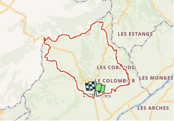
vinsobres

collot
User

Length
18.3 km

Max alt
491 m

Uphill gradient
406 m
Km-Effort
24 km

Min alt
266 m

Downhill gradient
389 m
Boucle
No
Creation date :
2021-10-02 07:38:58.064
Updated on :
2022-10-13 18:58:43.497
7h21
Difficulty : Medium

FREE GPS app for hiking
 SityTrail
IGN / Geographical institutes
SityTrail Plus
The world is yours!
About
Trail Walking of 18.3 km to be discovered at Auvergne-Rhône-Alpes, Drôme, Vinsobres. This trail is proposed by collot.
Positioning
Country:
France
Region :
Auvergne-Rhône-Alpes
Department/Province :
Drôme
Municipality :
Vinsobres
Location:
Unknown
Start:(Dec)
Start:(UTM)
664164 ; 4910786 (31T) N.
Comments