


CHA - J15 - 24/09 - Chatenay > Pérouges - R

aeldin
User
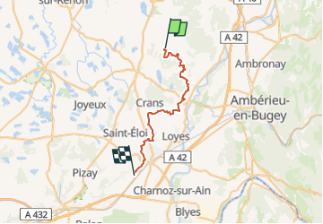

Length
29 km

Max alt
328 m

Uphill gradient
334 m
Km-Effort
33 km

Min alt
213 m

Downhill gradient
415 m
Boucle
No
Creation date :
2022-10-15 13:00:48.855
Updated on :
2022-10-15 13:02:29.252
58m
Difficulty : Easy

FREE GPS app for hiking
 SityTrail
IGN / Geographical institutes
SityTrail Plus
The world is yours!
About
Trail Horseback riding of 29 km to be discovered at Auvergne-Rhône-Alpes, Ain, Châtenay. This trail is proposed by aeldin.

Positioning
Country:
France
Region :
Auvergne-Rhône-Alpes
Department/Province :
Ain
Municipality :
Châtenay
Location:
Unknown
Start:(Dec)
Start:(UTM)
671432 ; 5098814 (31T) N.
Comments