


Boves

lefrancm
User
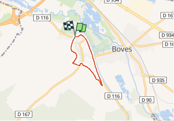

Length
3.6 km

Max alt
74 m

Uphill gradient
54 m
Km-Effort
4.3 km

Min alt
28 m

Downhill gradient
55 m
Boucle
Yes
Creation date :
2022-10-16 15:19:12.0
Updated on :
2022-10-16 16:23:40.071
1h04
Difficulty : Easy

FREE GPS app for hiking
 SityTrail
IGN / Geographical institutes
SityTrail Plus
The world is yours!
About
Trail Walking of 3.6 km to be discovered at Hauts-de-France, Somme, Boves. This trail is proposed by lefrancm.
Positioning
Country:
France
Region :
Hauts-de-France
Department/Province :
Somme
Municipality :
Boves
Location:
Unknown
Start:(Dec)
Start:(UTM)
455185 ; 5521997 (31U) N.
Comments