


faite13/10/2022 gorges de l'areuse

gerardmicheline
User
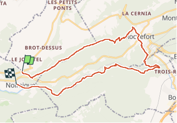

Length
22 km

Max alt
1284 m

Uphill gradient
741 m
Km-Effort
32 km

Min alt
489 m

Downhill gradient
1008 m
Boucle
No
Creation date :
2022-10-13 06:44:32.733
Updated on :
2022-10-17 11:24:45.089
5h53
Difficulty : Very difficult

FREE GPS app for hiking
 SityTrail
IGN / Geographical institutes
SityTrail Plus
The world is yours!
About
Trail Walking of 22 km to be discovered at Neuchâtel, Unknown, Val-de-Travers. This trail is proposed by gerardmicheline.
Positioning
Country:
Switzerland
Region :
Neuchâtel
Department/Province :
Unknown
Municipality :
Val-de-Travers
Location:
Unknown
Start:(Dec)
Start:(UTM)
327022 ; 5203351 (32T) N.
Comments