


st agnes

JPS73
User
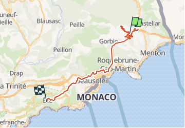

Length
26 km

Max alt
734 m

Uphill gradient
1455 m
Km-Effort
45 km

Min alt
106 m

Downhill gradient
1346 m
Boucle
No
Creation date :
2022-10-17 09:41:01.756
Updated on :
2022-10-17 14:48:42.455
2h47
Difficulty : Very difficult

FREE GPS app for hiking
 SityTrail
IGN / Geographical institutes
SityTrail Plus
The world is yours!
About
Trail Walking of 26 km to be discovered at Provence-Alpes-Côte d'Azur, Maritime Alps, Sainte-Agnès. This trail is proposed by JPS73.
Positioning
Country:
France
Region :
Provence-Alpes-Côte d'Azur
Department/Province :
Maritime Alps
Municipality :
Sainte-Agnès
Location:
Unknown
Start:(Dec)
Start:(UTM)
377116 ; 4850139 (32T) N.
Comments