


belley rive droite

Henri.Vekemans
User
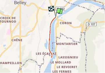

Length
4 km

Max alt
241 m

Uphill gradient
43 m
Km-Effort
4.6 km

Min alt
226 m

Downhill gradient
42 m
Boucle
Yes
Creation date :
2022-10-18 13:25:34.634
Updated on :
2022-10-18 14:22:41.521
56m
Difficulty : Easy

FREE GPS app for hiking
 SityTrail
IGN / Geographical institutes
SityTrail Plus
The world is yours!
About
Trail Walking of 4 km to be discovered at Auvergne-Rhône-Alpes, Ain, Belley. This trail is proposed by Henri.Vekemans.
Positioning
Country:
France
Region :
Auvergne-Rhône-Alpes
Department/Province :
Ain
Municipality :
Belley
Location:
Unknown
Start:(Dec)
Start:(UTM)
710530 ; 5070330 (31T) N.
Comments