


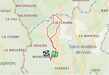
Montagnac Fontbonne

pb07
User

Length
5.3 km

Max alt
674 m

Uphill gradient
178 m
Km-Effort
7.6 km

Min alt
559 m

Downhill gradient
177 m
Boucle
Yes
Creation date :
2022-10-19 12:37:59.859
Updated on :
2022-10-19 14:26:02.895
1h47
Difficulty : Medium

FREE GPS app for hiking
 SityTrail
IGN / Geographical institutes
SityTrail Plus
The world is yours!
About
Trail Walking of 5.3 km to be discovered at Auvergne-Rhône-Alpes, Ardèche, Saint-Andéol-de-Vals. This trail is proposed by pb07.
Positioning
Country:
France
Region :
Auvergne-Rhône-Alpes
Department/Province :
Ardèche
Municipality :
Saint-Andéol-de-Vals
Location:
Unknown
Start:(Dec)
Start:(UTM)
609621 ; 4949131 (31T) N.
Comments