


peille

JPS73
User
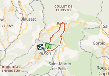

Length
9.8 km

Max alt
729 m

Uphill gradient
570 m
Km-Effort
17.5 km

Min alt
352 m

Downhill gradient
576 m
Boucle
Yes
Creation date :
2022-10-19 12:36:41.457
Updated on :
2022-10-19 16:48:01.652
2h48
Difficulty : Difficult

FREE GPS app for hiking
 SityTrail
IGN / Geographical institutes
SityTrail Plus
The world is yours!
About
Trail Walking of 9.8 km to be discovered at Provence-Alpes-Côte d'Azur, Maritime Alps, Peillon. This trail is proposed by JPS73.
Positioning
Country:
France
Region :
Provence-Alpes-Côte d'Azur
Department/Province :
Maritime Alps
Municipality :
Peillon
Location:
Unknown
Start:(Dec)
Start:(UTM)
369772 ; 4848542 (32T) N.
Comments