Trail Walking Calp - Ruta de las agua  Sella - Photo
© OpenStreetMap contributors
Length
Length
476 km
Max alt
Max alt
1303 m
Uphill gradient
Uphill gradient
15908 m
Km-Effort
Km-Effort  
689 km
Min alt
Min alt
0 m
Downhill gradient
Downhill gradient
15958 m
Boucle
Boucle
No
Creation date :
2022-05-27 09:05:37.092
Updated on :
2022-10-20 09:41:54.155

(0 Reviews)

Walking
Walking
791h10
Difficulty : Very difficult

Scan this QR Code to open this trail in the SityTrail application

FREE GPS app for hiking

Logo SityTrail SityTrail

IGN / Geographical institutes

Download SityTrail from the App Store Download SityTrail from Google Play

Logo SityTrail SityTrail World

The world is yours!

Download SityTrail from the App Store Download SityTrail from Google Play Download SityTrail on Huawei AppGallery

About

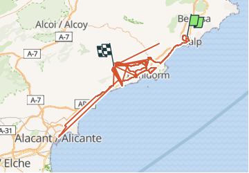
Trail Walking of 476 km to be discovered at Valencian Community, Alacant / Alicante, Calp. This trail is proposed by cici58007.

Description

Andando

Elevation profile

Positioning

Country:
Spain
Region :
Valencian Community
Department/Province :
Alacant / Alicante
Municipality :
Calp
Location:
Unknown
Start:(UTM)
241196 ; 4283054 (31S) N.

Trails nearby

Trail Walking Calp - Sierra de Olta - Photo
Walking
cici58007

Walking

Medium
Calp, Valencian Community, Alacant / Alicante, Spain
7.7 km | 11.8 km-effort
3h 15min
Yes
Trail Other activity Calp - Spain - Calpe - Olta roundtour - Photo
Other activity
ErikC

Other activity

Easy
Calp, Valencian Community, Alacant / Alicante, Spain
7.4 km | 11.4 km-effort
3h 24min
Yes
Trail Road bike Calp - vélo  - Photo
Road bike
HENRY83

Road bike

Medium
Calp, Valencian Community, Alacant / Alicante, Spain
51 km | 62 km-effort
2h 45min
Yes
Trail Walking Calp - Calpe  - Photo
Walking
HENRY83

Walking

Medium
Calp, Valencian Community, Alacant / Alicante, Spain
7.9 km | 9.7 km-effort
1h 33min
Yes
Trail Walking Llíber - Marnes  Pinos - Photo
Walking
andre.forthomme@gmail.com

Walking

Medium
Llíber, Valencian Community, Alacant / Alicante, Spain
9.3 km | 13.1 km-effort
2h 35min
Yes
Trail Walking Calp - w-spanje-calpe-naar-de-mirador - Photo
Walking
gpstracks

Walking

Very easy
Calp, Valencian Community, Alacant / Alicante, Spain
8.2 km | 17.4 km-effort
Unknown
Yes
Trail Walking Llíber - pinos - Photo
Walking
andre.forthomme@gmail.com

Walking

Medium
Llíber, Valencian Community, Alacant / Alicante, Spain
8.3 km | 11.2 km-effort
2h 37min
Yes
Trail Walking Calp - serra de olta - Photo
Walking
andre.forthomme@gmail.com

Walking

Medium
Calp, Valencian Community, Alacant / Alicante, Spain
8.9 km | 12.9 km-effort
2h 50min
Yes
Trail Car Calp - camping montagne calp - Photo
Car
andre.forthomme@gmail.com

Car

Very easy
Calp, Valencian Community, Alacant / Alicante, Spain
6.9 km | 8.1 km-effort
24min
No


Close
My subscriptions