


6.09.2014

robertserre
User

Length
14.2 km

Max alt
109 m

Uphill gradient
168 m
Km-Effort
16.4 km

Min alt
25 m

Downhill gradient
168 m
Boucle
Yes
Creation date :
2014-12-10 00:00:00.0
Updated on :
2014-12-10 00:00:00.0
3h33
Difficulty : Easy

FREE GPS app for hiking
 SityTrail
IGN / Geographical institutes
SityTrail Plus
The world is yours!
About
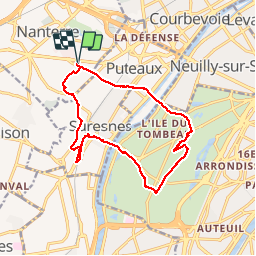
Trail Walking of 14.2 km to be discovered at Ile-de-France, Hauts-de-Seine, Nanterre. This trail is proposed by robertserre.
Positioning
Country:
France
Region :
Ile-de-France
Department/Province :
Hauts-de-Seine
Municipality :
Nanterre
Location:
Unknown
Start:(Dec)
Start:(UTM)
442648 ; 5414979 (31U) N.
Comments