Trail Walking Espeluche - 2022-10-20_15h14m37_GPX-Bois-Jamot-Espeluche - Photo

2022-10-20_15h14m37_GPX-Bois-Jamot-Espeluche

 chancha
chancha

User

© OpenStreetMap contributors
Length
Length
11.3 km
Max alt
Max alt
405 m
Uphill gradient
Uphill gradient
308 m
Km-Effort
Km-Effort  
15.4 km
Min alt
Min alt
161 m
Downhill gradient
Downhill gradient
309 m
Boucle
Boucle
Yes
Creation date :
2022-10-20 13:14:37.242
Updated on :
2022-10-20 16:35:52.084

(1 Reviews)

Walking
Walking
3h28
Difficulty : Medium

Scan this QR Code to open this trail in the SityTrail application

FREE GPS app for hiking

Logo SityTrail SityTrail

IGN / Geographical institutes

Download SityTrail from the App Store Download SityTrail from Google Play

Logo SityTrail SityTrail World

The world is yours!

Download SityTrail from the App Store Download SityTrail from Google Play Download SityTrail on Huawei AppGallery

About

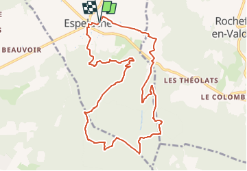
Trail Walking of 11.3 km to be discovered at Auvergne-Rhône-Alpes, Drôme, Espeluche. This trail is proposed by chancha.

Description

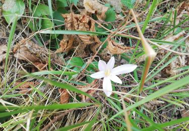
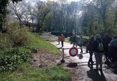
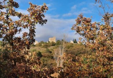
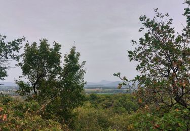
Entre chemins forestiers et sentiers en crête  , le bois Jamot offre de jolis points de vue sur le château medieval de Rochefort-en-Valdaine ainsi que la vallée du Rhône  . Une randonnée accessible et majoritairement ombragée .

Elevation profile

Photos

Positioning

Country:
France
Region :
Auvergne-Rhône-Alpes
Department/Province :
Drôme
Municipality :
Espeluche
Location:
Unknown
Start:(UTM)
645132 ; 4930863 (31T) N.

Comments

Please log in to post a review or rate the element


Trails nearby

Trail Walking Allan - allan transclavienne rac - Photo
Walking
micheleuvrard

Walking

Very easy
(1)
Allan, Auvergne-Rhône-Alpes, Drôme, France
19.1 km | 26 km-effort
5h 11min
Yes
Trail Mountain bike Puygiron - Puygiron VTT n°5 - Photo
Mountain bike
tracegps

Mountain bike

Very difficult
(1)
Puygiron, Auvergne-Rhône-Alpes, Drôme, France
47 km | 60 km-effort
3h 0min
Yes
Trail Walking La Touche - Citelles hameau et ruisseaux 10km - Photo
Walking
GUIDE
thonyc

Walking

Easy
(2)
La Touche, Auvergne-Rhône-Alpes, Drôme, France
9.6 km | 12.6 km-effort
3h 7min
Yes
Trail sport Allan - SityTrail - Les Villages Perchés. - Photo
sport
collot

sport

Very easy
(1)
Allan, Auvergne-Rhône-Alpes, Drôme, France
19.5 km | 27 km-effort
Unknown
Yes
Trail Walking Montboucher-sur-Jabron - 20240428 Rando vieux  - Photo
Walking
Havani

Walking

Very easy
Montboucher-sur-Jabron, Auvergne-Rhône-Alpes, Drôme, France
6.1 km | 6.5 km-effort
5h 17min
Yes
Trail Walking Rochefort-en-Valdaine - tmpWriteApidae_267713_fr - Photo
Walking
GUIDE
thonyc

Walking

Easy
Rochefort-en-Valdaine, Auvergne-Rhône-Alpes, Drôme, France
7.3 km | 10.3 km-effort
2h 30min
Yes
Trail Walking Allan - Allan Château de Rochefort en Valdaine - Photo
Walking
TOULAUDIN

Walking

Easy
Allan, Auvergne-Rhône-Alpes, Drôme, France
17.7 km | 26 km-effort
6h 6min
Yes
Trail Walking La Touche - La Touche : Les Citelles et Serre Pointu 12km - Photo
Walking
chancha

Walking

Difficult
La Touche, Auvergne-Rhône-Alpes, Drôme, France
12 km | 16.6 km-effort
4h 3min
Yes
Trail Walking La Touche - La Touche Mastaize 9km - Photo
Walking
chancha

Walking

Difficult
La Touche, Auvergne-Rhône-Alpes, Drôme, France
8.6 km | 10.7 km-effort
3h 24min
Yes


Close
My subscriptions