


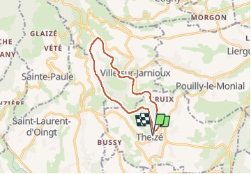
Theizé (11 km - D. 310 m)

Thomasdanielle
User

Length
11.3 km

Max alt
650 m

Uphill gradient
309 m
Km-Effort
15.5 km

Min alt
404 m

Downhill gradient
308 m
Boucle
Yes
Creation date :
2022-10-20 12:11:10.0
Updated on :
2023-03-22 11:01:12.346
2h43
Difficulty : Medium

FREE GPS app for hiking
 SityTrail
IGN / Geographical institutes
SityTrail Plus
The world is yours!
About
Trail Walking of 11.3 km to be discovered at Auvergne-Rhône-Alpes, Rhône, Theizé. This trail is proposed by Thomasdanielle.
Description
D/A Parking "Place des randonneurs"
Photos
 - Photo 1")
 - Photo 2")
 - Photo 3")
Positioning
Country:
France
Region :
Auvergne-Rhône-Alpes
Department/Province :
Rhône
Municipality :
Theizé
Location:
Unknown
Start:(Dec)
Start:(UTM)
625406 ; 5088712 (31T) N.
Comments