


2014-09-06 morigny champigny 60km

Lucquiaud
User
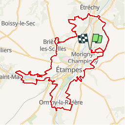

Length
56 km

Max alt
154 m

Uphill gradient
997 m
Km-Effort
69 km

Min alt
62 m

Downhill gradient
997 m
Boucle
Yes
Creation date :
2018-09-15 15:06:33.407
Updated on :
2018-09-15 15:06:33.727
6h26
Difficulty : Difficult

FREE GPS app for hiking
 SityTrail
IGN / Geographical institutes
SityTrail Plus
The world is yours!
About
Trail Mountain bike of 56 km to be discovered at Ile-de-France, Essonne, Morigny-Champigny. This trail is proposed by Lucquiaud.
Description
parcours intéressant, très varié, avec des sigles, des raidillons, du plat
Positioning
Country:
France
Region :
Ile-de-France
Department/Province :
Essonne
Municipality :
Morigny-Champigny
Location:
Unknown
Start:(Dec)
Start:(UTM)
440216 ; 5367021 (31U) N.
Comments