


les Hauts butees

Superpape
User

Length
15.5 km

Max alt
460 m

Uphill gradient
283 m
Km-Effort
19.5 km

Min alt
215 m

Downhill gradient
364 m
Boucle
No
Creation date :
2022-10-20 12:44:05.998
Updated on :
2022-10-20 16:04:23.211
2h59
Difficulty : Medium

FREE GPS app for hiking
 SityTrail
IGN / Geographical institutes
SityTrail Plus
The world is yours!
About
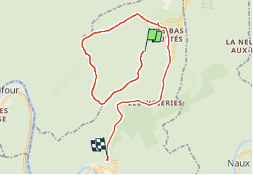
Trail Walking of 15.5 km to be discovered at Grand Est, Ardennes, Monthermé. This trail is proposed by Superpape.
Positioning
Country:
France
Region :
Grand Est
Department/Province :
Ardennes
Municipality :
Monthermé
Location:
Unknown
Start:(Dec)
Start:(UTM)
626405 ; 5531720 (31U) N.
Comments