


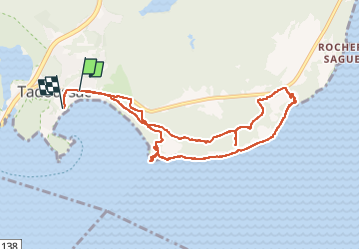
tadoussac

Benoît66
User

Length
9.5 km

Max alt
79 m

Uphill gradient
178 m
Km-Effort
11.9 km

Min alt
0 m

Downhill gradient
201 m
Boucle
No
Creation date :
2022-10-16 19:31:23.607
Updated on :
2022-10-22 09:20:15.476
2h20
Difficulty : Easy

FREE GPS app for hiking
 SityTrail
IGN / Geographical institutes
SityTrail Plus
The world is yours!
About
Trail Walking of 9.5 km to be discovered at Quebec, La Haute-Côte-Nord, Tadoussac. This trail is proposed by Benoît66.
Description
sentier
Positioning
Country:
Canada
Region :
Quebec
Department/Province :
La Haute-Côte-Nord
Municipality :
Tadoussac
Location:
Unknown
Start:(Dec)
Start:(UTM)
446959 ; 5332485 (19U) N.
Comments