


TEM77 en ligne v3
TEM77
Les randos de la TEM77

Length
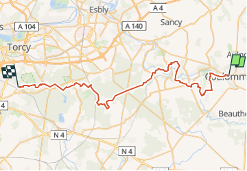
52 km

Max alt
138 m

Uphill gradient
588 m
Km-Effort
60 km

Min alt
58 m

Downhill gradient
551 m
Boucle
No
Creation date :
2022-10-23 07:10:04.999
Updated on :
2022-12-16 18:05:34.308
2h53
Difficulty : Difficult

FREE GPS app for hiking
 SityTrail
IGN / Geographical institutes
SityTrail Plus
The world is yours!
About
Trail Walking of 52 km to be discovered at Ile-de-France, Seine-et-Marne, Coulommiers. This trail is proposed by TEM77.
Positioning
Country:
France
Region :
Ile-de-France
Department/Province :
Seine-et-Marne
Municipality :
Coulommiers
Location:
Unknown
Start:(Dec)
Start:(UTM)
505426 ; 5406547 (31U) N.
Comments