


col bassachaux lindarets

naskur
User
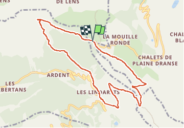

Length
10.1 km

Max alt
1943 m

Uphill gradient
528 m
Km-Effort
17.1 km

Min alt
1451 m

Downhill gradient
529 m
Boucle
Yes
Creation date :
2022-10-23 07:39:48.52
Updated on :
2022-10-23 11:16:01.963
2h47
Difficulty : Medium

FREE GPS app for hiking
 SityTrail
IGN / Geographical institutes
SityTrail Plus
The world is yours!
About
Trail Walking of 10.1 km to be discovered at Auvergne-Rhône-Alpes, Upper Savoy, Abondance. This trail is proposed by naskur.
Description
la faire dans l'autre sens
Positioning
Country:
France
Region :
Auvergne-Rhône-Alpes
Department/Province :
Upper Savoy
Municipality :
Abondance
Location:
Unknown
Start:(Dec)
Start:(UTM)
328181 ; 5121181 (32T) N.
Comments