


CLD - MM Le 25/10/2022

JackPG
User
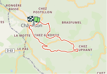

Length
7.1 km

Max alt
583 m

Uphill gradient
315 m
Km-Effort
11.3 km

Min alt
314 m

Downhill gradient
315 m
Boucle
Yes
Creation date :
2022-10-26 06:13:42.832
Updated on :
2022-10-26 06:14:15.244
2h33
Difficulty : Medium

FREE GPS app for hiking
 SityTrail
IGN / Geographical institutes
SityTrail Plus
The world is yours!
About
Trail Walking of 7.1 km to be discovered at Auvergne-Rhône-Alpes, Puy-de-Dôme, Châteldon. This trail is proposed by JackPG.
Positioning
Country:
France
Region :
Auvergne-Rhône-Alpes
Department/Province :
Puy-de-Dôme
Municipality :
Châteldon
Location:
Unknown
Start:(Dec)
Start:(UTM)
540403 ; 5091565 (31T) N.
Comments