


Rouge eau variante

iznogud
User
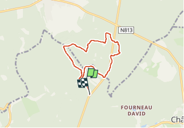

Length
5.9 km

Max alt
359 m

Uphill gradient
103 m
Km-Effort
7.3 km

Min alt
310 m

Downhill gradient
92 m
Boucle
No
Creation date :
2022-10-26 09:02:54.0
Updated on :
2022-10-26 10:46:02.072
1h42
Difficulty : Medium

FREE GPS app for hiking
 SityTrail
IGN / Geographical institutes
SityTrail Plus
The world is yours!
About
Trail Walking of 5.9 km to be discovered at Wallonia, Luxembourg, Saint-Léger. This trail is proposed by iznogud.
Positioning
Country:
Belgium
Region :
Wallonia
Department/Province :
Luxembourg
Municipality :
Saint-Léger
Location:
Saint-Léger
Start:(Dec)
Start:(UTM)
692388 ; 5501255 (31U) N.
Comments