


gy en Sologne

lecmic
User
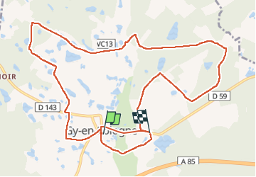

Length
13.2 km

Max alt
115 m

Uphill gradient
105 m
Km-Effort
14.6 km

Min alt
80 m

Downhill gradient
101 m
Boucle
No
Creation date :
2022-10-27 06:36:31.36
Updated on :
2022-10-27 09:36:34.052
2h59
Difficulty : Easy

FREE GPS app for hiking
 SityTrail
IGN / Geographical institutes
SityTrail Plus
The world is yours!
About
Trail Walking of 13.2 km to be discovered at Centre-Loire Valley, Loir-et-Cher, Gy-en-Sologne. This trail is proposed by lecmic.
Description
fanxo
Positioning
Country:
France
Region :
Centre-Loire Valley
Department/Province :
Loir-et-Cher
Municipality :
Gy-en-Sologne
Location:
Unknown
Start:(Dec)
Start:(UTM)
393017 ; 5244344 (31T) N.
Comments