


CLERY - DRY AR

sylbois
User
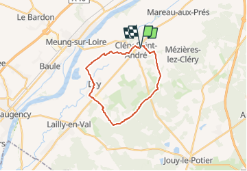

Length
20 km

Max alt
110 m

Uphill gradient
114 m
Km-Effort
22 km

Min alt
83 m

Downhill gradient
115 m
Boucle
Yes
Creation date :
2022-10-27 15:05:06.745
Updated on :
2022-10-27 15:06:17.031
4h53
Difficulty : Very difficult

FREE GPS app for hiking
 SityTrail
IGN / Geographical institutes
SityTrail Plus
The world is yours!
About
Trail Walking of 20 km to be discovered at Centre-Loire Valley, Loiret, Cléry-Saint-André. This trail is proposed by sylbois.
Positioning
Country:
France
Region :
Centre-Loire Valley
Department/Province :
Loiret
Municipality :
Cléry-Saint-André
Location:
Unknown
Start:(Dec)
Start:(UTM)
407320 ; 5297361 (31T) N.
Comments