


astros rando reconnaissance du 28 octobre ^pour club

clintest
User

Length
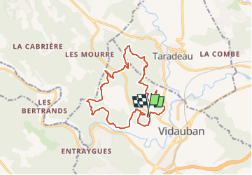
16.9 km

Max alt
213 m

Uphill gradient
423 m
Km-Effort
23 km

Min alt
64 m

Downhill gradient
430 m
Boucle
Yes
Creation date :
2022-10-28 14:41:48.515
Updated on :
2022-10-28 14:42:43.827
5h07
Difficulty : Very difficult

FREE GPS app for hiking
 SityTrail
IGN / Geographical institutes
SityTrail Plus
The world is yours!
About
Trail Walking of 16.9 km to be discovered at Provence-Alpes-Côte d'Azur, Var, Vidauban. This trail is proposed by clintest.
Positioning
Country:
France
Region :
Provence-Alpes-Côte d'Azur
Department/Province :
Var
Municipality :
Vidauban
Location:
Unknown
Start:(Dec)
Start:(UTM)
290749 ; 4812109 (32T) N.
Comments