Trail Walking Cernex - PM CERNEX Veyssières Autour du BOIS CHARDON - Photo

PM CERNEX Veyssières Autour du BOIS CHARDON

 jomac
jomac

User

© OpenStreetMap contributors
Length
Length
4.3 km
Max alt
Max alt
597 m
Uphill gradient
Uphill gradient
117 m
Km-Effort
Km-Effort  
5.9 km
Min alt
Min alt
497 m
Downhill gradient
Downhill gradient
113 m
Boucle
Boucle
Yes
Creation date :
2022-10-29 08:01:17.083
Updated on :
2023-04-11 14:08:00.048

(0 Reviews)

Walking
Walking
1h19
Difficulty : Easy

Scan this QR Code to open this trail in the SityTrail application

FREE GPS app for hiking

Logo SityTrail SityTrail

IGN / Geographical institutes

Download SityTrail from the App Store Download SityTrail from Google Play

Logo SityTrail SityTrail World

The world is yours!

Download SityTrail from the App Store Download SityTrail from Google Play Download SityTrail on Huawei AppGallery

About

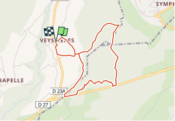
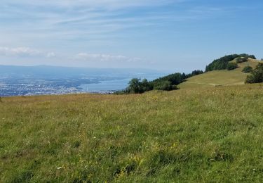
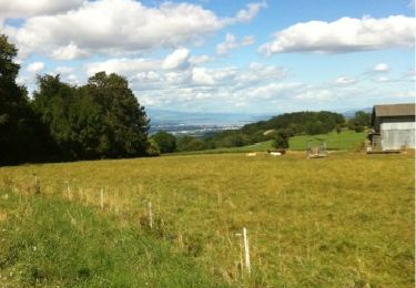
Trail Walking of 4.3 km to be discovered at Auvergne-Rhône-Alpes, Upper Savoy, Cernex. This trail is proposed by jomac.

Elevation profile

Positioning

Country:
France
Region :
Auvergne-Rhône-Alpes
Department/Province :
Upper Savoy
Municipality :
Cernex
Location:
Unknown
Start:(UTM)
271266 ; 5103979 (32T) N.

Trails nearby

Trail Walking Présilly - 27-04-2022 Maison et Plan du Salève-Mont Sion  - Photo
Walking
GUIDE
Kargil

Walking

Difficult
Présilly, Auvergne-Rhône-Alpes, Upper Savoy, France
20 km | 32 km-effort
5h 15min
Yes
Trail Walking Marlioz - 22-03-2022 Marlioz - Les Usses - Photo
Walking
GUIDE
Kargil

Walking

Medium
Marlioz, Auvergne-Rhône-Alpes, Upper Savoy, France
22 km | 28 km-effort
4h 36min
Yes
Trail Walking Contamine-Sarzin - Contamine Sarzin Cascade Barbannaz - Photo
Walking
Petitchaperonvert

Walking

Medium
Contamine-Sarzin, Auvergne-Rhône-Alpes, Upper Savoy, France
8.6 km | 13.8 km-effort
2h 49min
Yes
Trail Mountain bike Saint-Blaise - Tour du saleve depuis saint blaise - Photo
Mountain bike
Ben Garcia

Mountain bike

Difficult
Saint-Blaise, Auvergne-Rhône-Alpes, Upper Savoy, France
23 km | 35 km-effort
2h 31min
Yes
Trail Via ferrata Présilly - via ferrata revaclier st Julien en Genevois - Photo
Via ferrata
sallycorne

Via ferrata

Medium
Présilly, Auvergne-Rhône-Alpes, Upper Savoy, France
2.2 km | 6 km-effort
1h 1min
Yes
Trail Mountain bike Vers - la motte cernex charley - Photo
Mountain bike
philippe.michel10

Mountain bike

Very easy
Vers, Auvergne-Rhône-Alpes, Upper Savoy, France
11.5 km | 15.8 km-effort
1h 2min
Yes
Trail Walking Présilly - La Chartreuse de Pomier - Présilly - Photo
Walking
tracegps

Walking

Easy
Présilly, Auvergne-Rhône-Alpes, Upper Savoy, France
2.5 km | 3.4 km-effort
40min
Yes
Trail Walking Saint-Blaise - De Charly [74350-Haute-Savoie] à Chaumont [74270-Haute-Savoie] - Photo
Walking
phimar_2612

Walking

Very difficult
Saint-Blaise, Auvergne-Rhône-Alpes, Upper Savoy, France
21 km | 27 km-effort
4h 55min
No
Trail Walking Cruseilles - chosal - Photo
Walking
Bugeat

Walking

Medium
Cruseilles, Auvergne-Rhône-Alpes, Upper Savoy, France
15.3 km | 21 km-effort
4h 16min
Yes


Close
My subscriptions